<< Back to Map Development Forum   Search

Posts 51 - 70 of 148   <<Prev   1  2  3  4  5  6  7  8  Next >>   
I have returned (Plus new map): 4/19/2016 22:12:34


Жұқтыру
Level 56
Report
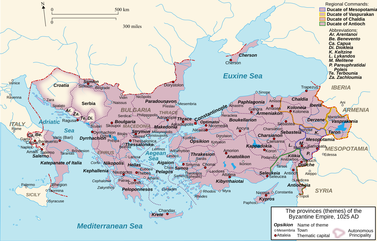
Wow, that's a lot to get on with. Thanks for helping! By the way, some of the spellings your were concerned about may be covered here: https://upload.wikimedia.org/wikipedia/commons/thumb/c/cb/Byzantine_Empire_Themes_1025-en.svg/1280px-Byzantine_Empire_Themes_1025-en.svg.png
This is what I used for the Byzantine territories.


Ah, this map is helpful, but I still don't see Pareuphratidai (southeast Turkey), nor Pelagos (Kyklades islands), nor Aigaion (Aigaion was the name of the whole thema, which the land does not have all of)

Charsiannon -> Charsianon
Teluch -> Antiocheia tou Taurou (seems like the weighty borough), or Telych (consistent)
Kephallenia
Achaea -> Thiva (Achaea is on Peloponessos?)
Larissa -> Larisa
Thessalonike
Strymon
Epirus (bonus) -> Epeiros (Greek name)
Nikopolis
Prespa -> Konstantia (officially renamed this after Greek taking in 1018)
Dyrrhachion
Constantinople -> Konstantinoupolis/Konstantinoupole (both names were wielded)
Phillippopolis
Moysnopolis -> Adrianoupolis (very weighty borough)
Paradounavon -> Dourostolon (there is a whole bunch of iffy information on the Paradounavon (or -bon) theme, it's not even sure if it was founded at this map's time or how big was it, so best be safe and go with the weightiest borough there at the time, which was Dourostolon/Silistra. It might have also been named Theodoropolis at this time, but I think the name wore off by now)
Makedonia -> Prilapos (you're attributing loads of land to Makedonia, and not attributing some core elements. Just call it the biggest borough there, Prilapos/Prilep)
Serdica -> Triaditza (Serdica is the old Latin name, this is middle Greek name)
Naissus -> Nissa
Inner Serbia -> Ras
Outer Serbia -> Syrmia
Dioklia -> Diokleia
(Principality of) Dalmatias -> Dalmatia
Calabria -> Kalabria
Puglia -> Apoulia
I have returned (Plus new map): 4/19/2016 23:17:15


Жұқтыру
Level 56
Report
Hungary: The only official tongue (for a very long time) was Latin, but Hungary allowed all kinds of tongues to be spoken, so I will put both Latin and the autonym.

Bratislava (bonus) -> Strigonium/Esztergom (weightier borough)
Sopron (bonus) -> Sopronium/Sopron
Buda (bonus)
Transilvania (bonus) -> Transsilvania/Transilvania
Pozsony -> Posonium/Prešporok
Heves -> Agria/Eger (weightier borough)
Zólyom -> Vetusolium/Zvolen
Gömöres Kis-Hont -> Gomorinum/Gömör (the fusion of these two countries had not been done yet)
Zemplén -> Zemplinum/Zemplén
Máramaros -> Marmatia/Máramaros
Szolnok-Doboka -> Dabacum?/Doboka
Maros-Torda -> Claudiopolis/Kolozs
Fogars -> Fogaras/Fogaras
Szeben -> Cibinium/Szeben
Hunyad -> Hunedoara/Hunedoara
Bihar -> Bihariensis/Bihar
Torontál -> Voivodina/Vajdaság
Békés -> Bekesiensis/Békés
Pest -> Alba Regia/Székesfehérvár (weightier borough)
Baranya -> Baraniensis/Baranya
Zala -> Soproniensis/Sopron
I have returned (Plus new map): 4/20/2016 00:47:04


zxctycxz [Ollie Bye] 
Level 59
Report
For those "weightier" ones, I can include city bonuses. I might need your advice on which cities to include, and what sort of bonuses values to use.
I have returned (Plus new map): 4/20/2016 01:48:40


Dr. Stupid 
Level 60
Report
I don't want to help, but I'm happy to see you back and am excited to play your map when it is completed. It's always nice to see quality maps being added!
I have returned (Plus new map): 4/20/2016 01:50:51


Жұқтыру
Level 56
Report
Holy Roman Empire:

Albing -> Holsteen
Heilanga -> Hamborg
Osterwalde -> Ostfalen
Ostphalia -> Hilmessen
Angaria -> Ossenbrügge
Westphalia -> Mönster
Frisia -> Fryslân
Threante -> Zwolle (no resultats showed for Threante?)
Maseland -> Utrecht (ditto)

More to come, also, yeah, I'll help with any weighting you need.
I have returned (Plus new map): 4/20/2016 01:52:25


Zephyrum
Level 60
Report
The only official tongue (for a very long time)


Juq, I know where your confusion comes from ("tongue" and "language" are also the same in Portuguese and many other languages), but "tongue" in english is exclusive to that thing inside your mouth. Language is the word you're looking for here :P
I have returned (Plus new map): 4/20/2016 02:01:03


The General
Level 51
Report
Wait who are you?
I have returned (Plus new map): 4/20/2016 02:05:29


Жұқтыру
Level 56
Report
Juq, I know where your confusion comes from ("tongue" and "language" are also the same in Portuguese and many other languages), but "tongue" in english is exclusive to that thing inside your mouth. Language is the word you're looking for here :P


But in English, too, and this is the true English word, from Germanic roots, not any weird Latinist roots. Unluckily (in my thought), the backstabber word is wielded more than the true root word.

https://en.wiktionary.org/wiki/tongue#Noun
I have returned (Plus new map): 4/20/2016 07:34:13


zxctycxz [Ollie Bye] 
Level 59
Report
in english is exclusive to that thing inside your mouth

I'd disagree, what about the phrase "mother tongue"?
I have returned (Plus new map): 4/20/2016 15:28:01


GeneralPE
Level 56
Report
Yeah, tongue can be language.
I have returned (Plus new map): 4/20/2016 17:52:55


zxctycxz [Ollie Bye] 
Level 59
Report
Update for Жұқтыру:

1) Such names as "Threante" came from a specific map I found that showed the K. Germany in the year 1000, I've avoided making some of those corrections, just so you can see the map first and check that the do still need to be changed: https://upload.wikimedia.org/wikipedia/commons/0/01/Droysens-22-23.jpg

2) Because of all your help, I will accredit you in the map as usual

3) I might start doing some cities soon, I'll come up with a preliminary list that you can review

4) With India, I've just given the territories codes for now, because I know the city names changed in the 1940s and 1950s, so I can't use Google Maps. If you wouldn't mind find names for India, that would be appreciated.
I have returned (Plus new map): 4/20/2016 21:58:25


Жұқтыру
Level 56
Report
1) Such names as "Threante" came from a specific map I found that showed the K. Germany in the year 1000, I've avoided making some of those corrections, just so you can see the map first and check that the do still need to be changed: https://upload.wikimedia.org/wikipedia/commons/0/01/Droysens-22-23.jpg

This is what I was going on, for Sachsen, anyway. https://upload.wikimedia.org/wikipedia/commons/4/49/Karte_Stammesherzogtum_Sachsen_um_1000.png?uselang=ru


Ah, this is helpful. Ok, I'll revise. Also, you might know this already, but take old maps of such times with some distrust. More historic research has been done, and the borders are more known than what they were before. Just on this map, I easily see that German and Latin are used kind of inconsistently.

Holsteen -> Noordalbingien
Hamborg
Osterwalde -> Merseburg
Ostphalia -> Hilmessen
Ossenbrügge
Westphalia -> Mönster
Threante -> Zwolle
Maseland -> Utrecht (possibly name it Holland, though it's a bit smaller than the land)

Solanki:

KS6 -> Surendranagar
KS7 -> Jamnagar
KS8 -> Junagadh
Gujarat (bonus) -> Saurashtra
KS1 -> Mewar

(more later)

Notes: Kutch is not an island.
I have returned (Plus new map): 4/21/2016 02:21:10


zxctycxz [Ollie Bye] 
Level 59
Report
Notes: Kutch is not an island.

It was before the 1800s, wasn't it?

-----------------------------------------------

Gujarat (bonus) -> Saurashtra

Is this just a more traditional name or something? The one called "Inner Gujarat" might also need some attention, I don't think it's very well named at the moment.

Edited 4/21/2016 02:26:38
I have returned (Plus new map): 4/21/2016 03:23:13


Жұқтыру
Level 56
Report
Notes: Kutch is not an island.

It was before the 1800s, wasn't it?


No, there were a few earthquakes there, but from what I read, it has only recently become a penninsula of kinds, never an island, show me why you think it is an island, though, I might be wrong.

https://upload.wikimedia.org/wikipedia/commons/6/65/Gujarat_Gulfs.jpg (Kutch is south of its Rann and north of its Gulf)

Is this just a more traditional name or something? The one called "Inner Gujarat" might also need some attention, I don't think it's very well named at the moment.


Gujarat usually refers to a bigger site - wherever the Gujarati culture is spread. However, Saraushta refers to the penninsula vicinity, and Kathiawar refers to the penninsula itself. I think Saraushta is the better name, though, as it has been attested very early on to refer to the site, while Kathiawar gets its name from the Kathi folk, who migrated there sometime in the 1200s to 1400s, and probably was coined later.

Also, yeah, I'll probably find a better name for "Inner Gujarat", but later.
I have returned (Plus new map): 4/21/2016 03:51:16


zxctycxz [Ollie Bye] 
Level 59
Report
show me why you think it is an island, though, I might be wrong.

A lot of antique maps show it as beign an island: http://homepages.rootsweb.ancestry.com/~poyntz/India/images/india_shepherd_1923.jpg
I don't know exactly when this ended, but it's still shown like this in 1815, but never by 1914, so probably some point in the 1800s.
I have returned (Plus new map): 4/21/2016 04:39:46


Жұқтыру
Level 56
Report
http://omniatlas.com/maps/southasia/

Not an island in 1902.

http://www.davidrumsey.com/luna/servlet/detail/RUMSEY~8~1~31565~1150044:-Hindoostan-north-;JSESSIONID=4f8b95ce-93c6-4439-84d1-ac1f5fff4208?showTip=false&showTipAdvancedSearch=false&title=Search+Results%3A+List_No+equal+to+%272310.059%27&thumbnailViewUrlKey=link.view.search.url&helpUrl=http%3A%2F%2Fdoc.lunaimaging.com%2Fdisplay%2FV71D%2FLUNA%2BViewer%23LUNAViewer-LUNAViewer&fullTextSearchChecked=&advancedSearchUrl=http%3A%2F%2Fdoc.lunaimaging.com%2Fdisplay%2FV71D%2FSearching%23Searching-Searching

Not in 1815.

http://www.davidrumsey.com/luna/servlet/detail/RUMSEY~8~1~28325~1120756:E--Hemisphere-?showTip=false&showTipAdvancedSearch=false&title=Search+Results%3A+List_No+equal+to+%271007.005%27&thumbnailViewUrlKey=link.view.search.url&helpUrl=http%3A%2F%2Fdoc.lunaimaging.com%2Fdisplay%2FV71D%2FLUNA%2BViewer%23LUNAViewer-LUNAViewer&fullTextSearchChecked=&advancedSearchUrl=http%3A%2F%2Fdoc.lunaimaging.com%2Fdisplay%2FV71D%2FSearching%23Searching-Searching

Map was made in 1804, doesn't show it as an island here.

http://digitool.is.cuni.cz:1801/view/action/nmets.do?DOCCHOICE=1013080.xml&dvs=1461211197940~683&locale=en_GB&search_terms=&adjacency=N&VIEWER_URL=/view/action/nmets.do?&DELIVERY_RULE_ID=3&divType=&usePid1=true&usePid2=true&COPYRIGHTS_DISPLAY_FILE=licence_mapy

No island here (1785).

http://www.davidrumsey.com/luna/servlet/detail/RUMSEY~8~1~3656~420031:The-East-Indies,-with-the-roads--no?showTip=false&showTipAdvancedSearch=false&title=Search+Results%3A+List_No+equal+to+%270411.031%27&thumbnailViewUrlKey=link.view.search.url&helpUrl=http%3A%2F%2Fdoc.lunaimaging.com%2Fdisplay%2FV71D%2FLUNA%2BViewer%23LUNAViewer-LUNAViewer&fullTextSearchChecked=&advancedSearchUrl=http%3A%2F%2Fdoc.lunaimaging.com%2Fdisplay%2FV71D%2FSearching%23Searching-Searching

Not shown as an island here (1768).

https://www.google.com/maps/@23.416012,71.44288,3a,75y,90t/data=!3m8!1e2!3m6!1s101445112!2e1!3e10!6s%2F%2Flh3.googleusercontent.com%2Fproxy%2F7sryEuufJnXUR4gWgKDljYDAp7wkk2q0jcCAGF2bu6NysYKPHO2PGXE5D9wB6zE8ZYGDADlBvX5nKLuAbH_h6kKt24ukE_Q%3Dw203-h152!7i4608!8i3456

This is what the barrier between Kutch island and the mainland looks like today.

http://digitool.is.cuni.cz:1801/view/action/nmets.do?DOCCHOICE=809972.xml&dvs=1461211989065~639&locale=en_GB&search_terms=&adjacency=&VIEWER_URL=/view/action/nmets.do?&DELIVERY_RULE_ID=3&divType=&COPYRIGHTS_DISPLAY_FILE=licence_mapy

No island here (late 1600s)

http://biblio.unibe.ch/web-apps/maps/zoomify.php?pic=Ryh_1201_27.jpg&col=ryh

No island here (1669)

http://www.davidrumsey.com/luna/servlet/detail/RUMSEY~8~1~203940~3001735:Facsimile--World-by-Mercator-?showTip=false&showTipAdvancedSearch=false&title=Search+Results%3A+List_No+equal+to+%271122.021%27&thumbnailViewUrlKey=link.view.search.url&helpUrl=http%3A%2F%2Fdoc.lunaimaging.com%2Fdisplay%2FV71D%2FLUNA%2BViewer%23LUNAViewer-LUNAViewer&fullTextSearchChecked=&advancedSearchUrl=http%3A%2F%2Fdoc.lunaimaging.com%2Fdisplay%2FV71D%2FSearching%23Searching-Searching

No island here (1538, earliest decent map of the site I could find)

I think the maps that have it as an island just have a mistake of kinds, or maybe the marshes got flooded one year.

More:

https://upload.wikimedia.org/wikipedia/commons/0/09/Early_Gujarat_%28BC_250_to_1300_AD%29.jpg

https://upload.wikimedia.org/wikipedia/commons/d/d3/Province_of_Guzerat_Gujarat_India_1896.jpg

https://upload.wikimedia.org/wikipedia/commons/0/02/Cutch_State_British_India_1878.jpg (best representation, in my opinion)

https://upload.wikimedia.org/wikipedia/commons/1/1f/Hindoostanmap1812.jpg

https://www.google.com/maps/@22.2168574,72.6163888,3a,75y,90t/data=!3m8!1e2!3m6!1s-62KbkxJGMfo%2FVcS5nPLG78I%2FAAAAAAAAC9A%2FYJS38p_RABs!2e4!3e12!6s%2F%2Flh5.googleusercontent.com%2F-62KbkxJGMfo%2FVcS5nPLG78I%2FAAAAAAAAC9A%2FYJS38p_RABs%2Fs203-k-no%2F!7i6016!8i4000 (another photograph of the marshes)

https://www.google.com/maps/@23.372694,71.362976,3a,75y,90t/data=!3m8!1e2!3m6!1s46403334!2e1!3e10!6s%2F%2Flh4.googleusercontent.com%2Fproxy%2FDhgrK2G-06F8qexHg2x0ehpEWWrOFM0dbFZ_dyW7hTKMB2VtF_d4En0_X-erzg1k_zETpcKGYxBaqZPCk53DBHvsDmZigA%3Dw203-h135!7i1280!8i857 (one of the driest bits of the rann)

Edited 4/21/2016 05:02:17
I have returned (Plus new map): 4/21/2016 16:34:27


zxctycxz [Ollie Bye] 
Level 59
Report
Okay, I know what the problem is now: https://en.wikipedia.org/wiki/Great_Rann_of_Kutch

It's seasonal.
I have returned (Plus new map): 4/21/2016 22:07:41


zxctycxz [Ollie Bye] 
Level 59
Report
Another thought, if I changed "Chinese Civilisation" to "Buddhism", then all the states on the map would fit into one of the four bonuses. "Indian Civilisation" would then fittingly be changed to "Hinduism".
I have returned (Plus new map): 4/22/2016 20:19:20


҈ * TeeMee123҈ *
Level 55
Report
I have checked all the current territories.

The following missing connections are represented in this form:
Territory - Territory (Superbonus > Bonus1 - Bonus2)

Thurgau - Thurgal (HRE > Swabia - Bavaria),
Nordgau - Witawa (HRE > Bavaria - Bohemia),
Sung - Hei-Yu-Lin (Liao Dyn. > Chung),
Uigur Core - Hei-Yu-Lin (Liao Dyn. > Chung - Uigurs*),
Ashgabat - Balkanabat (Seljuks > Qazwin - Khurasan)

The uigurs bonus link does not show for some reason.

Edited 4/22/2016 20:20:01
I have returned (Plus new map): 4/25/2016 17:14:59


zxctycxz [Ollie Bye] 
Level 59
Report
This question is mainly for Жұқтыру, but anyone's free to answer. Should the Khazar Khanate be included? It's hard to tell whether it had collapsed by this point or not.
Posts 51 - 70 of 148   <<Prev   1  2  3  4  5  6  7  8  Next >>