<< Back to Map Development Forum   Search

Posts 61 - 80 of 148   <<Prev   1  2  3  4  5  6  7  8  Next >>   
I have returned (Plus new map): 4/20/2016 17:52:55


zxctycxz [Ollie Bye] 
Level 59
Report
Update for Жұқтыру:

1) Such names as "Threante" came from a specific map I found that showed the K. Germany in the year 1000, I've avoided making some of those corrections, just so you can see the map first and check that the do still need to be changed: https://upload.wikimedia.org/wikipedia/commons/0/01/Droysens-22-23.jpg

2) Because of all your help, I will accredit you in the map as usual

3) I might start doing some cities soon, I'll come up with a preliminary list that you can review

4) With India, I've just given the territories codes for now, because I know the city names changed in the 1940s and 1950s, so I can't use Google Maps. If you wouldn't mind find names for India, that would be appreciated.
I have returned (Plus new map): 4/20/2016 21:58:25


Жұқтыру
Level 56
Report
1) Such names as "Threante" came from a specific map I found that showed the K. Germany in the year 1000, I've avoided making some of those corrections, just so you can see the map first and check that the do still need to be changed: https://upload.wikimedia.org/wikipedia/commons/0/01/Droysens-22-23.jpg

This is what I was going on, for Sachsen, anyway. https://upload.wikimedia.org/wikipedia/commons/4/49/Karte_Stammesherzogtum_Sachsen_um_1000.png?uselang=ru


Ah, this is helpful. Ok, I'll revise. Also, you might know this already, but take old maps of such times with some distrust. More historic research has been done, and the borders are more known than what they were before. Just on this map, I easily see that German and Latin are used kind of inconsistently.

Holsteen -> Noordalbingien
Hamborg
Osterwalde -> Merseburg
Ostphalia -> Hilmessen
Ossenbrügge
Westphalia -> Mönster
Threante -> Zwolle
Maseland -> Utrecht (possibly name it Holland, though it's a bit smaller than the land)

Solanki:

KS6 -> Surendranagar
KS7 -> Jamnagar
KS8 -> Junagadh
Gujarat (bonus) -> Saurashtra
KS1 -> Mewar

(more later)

Notes: Kutch is not an island.
I have returned (Plus new map): 4/21/2016 02:21:10


zxctycxz [Ollie Bye] 
Level 59
Report
Notes: Kutch is not an island.

It was before the 1800s, wasn't it?

-----------------------------------------------

Gujarat (bonus) -> Saurashtra

Is this just a more traditional name or something? The one called "Inner Gujarat" might also need some attention, I don't think it's very well named at the moment.

Edited 4/21/2016 02:26:38
I have returned (Plus new map): 4/21/2016 03:23:13


Жұқтыру
Level 56
Report
Notes: Kutch is not an island.

It was before the 1800s, wasn't it?


No, there were a few earthquakes there, but from what I read, it has only recently become a penninsula of kinds, never an island, show me why you think it is an island, though, I might be wrong.

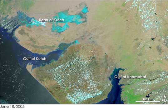
https://upload.wikimedia.org/wikipedia/commons/6/65/Gujarat_Gulfs.jpg (Kutch is south of its Rann and north of its Gulf)

Is this just a more traditional name or something? The one called "Inner Gujarat" might also need some attention, I don't think it's very well named at the moment.


Gujarat usually refers to a bigger site - wherever the Gujarati culture is spread. However, Saraushta refers to the penninsula vicinity, and Kathiawar refers to the penninsula itself. I think Saraushta is the better name, though, as it has been attested very early on to refer to the site, while Kathiawar gets its name from the Kathi folk, who migrated there sometime in the 1200s to 1400s, and probably was coined later.

Also, yeah, I'll probably find a better name for "Inner Gujarat", but later.
I have returned (Plus new map): 4/21/2016 03:51:16


zxctycxz [Ollie Bye] 
Level 59
Report
show me why you think it is an island, though, I might be wrong.

A lot of antique maps show it as beign an island: http://homepages.rootsweb.ancestry.com/~poyntz/India/images/india_shepherd_1923.jpg
I don't know exactly when this ended, but it's still shown like this in 1815, but never by 1914, so probably some point in the 1800s.
I have returned (Plus new map): 4/21/2016 04:39:46


Жұқтыру
Level 56
Report
http://omniatlas.com/maps/southasia/

Not an island in 1902.

http://www.davidrumsey.com/luna/servlet/detail/RUMSEY~8~1~31565~1150044:-Hindoostan-north-;JSESSIONID=4f8b95ce-93c6-4439-84d1-ac1f5fff4208?showTip=false&showTipAdvancedSearch=false&title=Search+Results%3A+List_No+equal+to+%272310.059%27&thumbnailViewUrlKey=link.view.search.url&helpUrl=http%3A%2F%2Fdoc.lunaimaging.com%2Fdisplay%2FV71D%2FLUNA%2BViewer%23LUNAViewer-LUNAViewer&fullTextSearchChecked=&advancedSearchUrl=http%3A%2F%2Fdoc.lunaimaging.com%2Fdisplay%2FV71D%2FSearching%23Searching-Searching

Not in 1815.

http://www.davidrumsey.com/luna/servlet/detail/RUMSEY~8~1~28325~1120756:E--Hemisphere-?showTip=false&showTipAdvancedSearch=false&title=Search+Results%3A+List_No+equal+to+%271007.005%27&thumbnailViewUrlKey=link.view.search.url&helpUrl=http%3A%2F%2Fdoc.lunaimaging.com%2Fdisplay%2FV71D%2FLUNA%2BViewer%23LUNAViewer-LUNAViewer&fullTextSearchChecked=&advancedSearchUrl=http%3A%2F%2Fdoc.lunaimaging.com%2Fdisplay%2FV71D%2FSearching%23Searching-Searching

Map was made in 1804, doesn't show it as an island here.

http://digitool.is.cuni.cz:1801/view/action/nmets.do?DOCCHOICE=1013080.xml&dvs=1461211197940~683&locale=en_GB&search_terms=&adjacency=N&VIEWER_URL=/view/action/nmets.do?&DELIVERY_RULE_ID=3&divType=&usePid1=true&usePid2=true&COPYRIGHTS_DISPLAY_FILE=licence_mapy

No island here (1785).

http://www.davidrumsey.com/luna/servlet/detail/RUMSEY~8~1~3656~420031:The-East-Indies,-with-the-roads--no?showTip=false&showTipAdvancedSearch=false&title=Search+Results%3A+List_No+equal+to+%270411.031%27&thumbnailViewUrlKey=link.view.search.url&helpUrl=http%3A%2F%2Fdoc.lunaimaging.com%2Fdisplay%2FV71D%2FLUNA%2BViewer%23LUNAViewer-LUNAViewer&fullTextSearchChecked=&advancedSearchUrl=http%3A%2F%2Fdoc.lunaimaging.com%2Fdisplay%2FV71D%2FSearching%23Searching-Searching

Not shown as an island here (1768).

https://www.google.com/maps/@23.416012,71.44288,3a,75y,90t/data=!3m8!1e2!3m6!1s101445112!2e1!3e10!6s%2F%2Flh3.googleusercontent.com%2Fproxy%2F7sryEuufJnXUR4gWgKDljYDAp7wkk2q0jcCAGF2bu6NysYKPHO2PGXE5D9wB6zE8ZYGDADlBvX5nKLuAbH_h6kKt24ukE_Q%3Dw203-h152!7i4608!8i3456

This is what the barrier between Kutch island and the mainland looks like today.

http://digitool.is.cuni.cz:1801/view/action/nmets.do?DOCCHOICE=809972.xml&dvs=1461211989065~639&locale=en_GB&search_terms=&adjacency=&VIEWER_URL=/view/action/nmets.do?&DELIVERY_RULE_ID=3&divType=&COPYRIGHTS_DISPLAY_FILE=licence_mapy

No island here (late 1600s)

http://biblio.unibe.ch/web-apps/maps/zoomify.php?pic=Ryh_1201_27.jpg&col=ryh

No island here (1669)

http://www.davidrumsey.com/luna/servlet/detail/RUMSEY~8~1~203940~3001735:Facsimile--World-by-Mercator-?showTip=false&showTipAdvancedSearch=false&title=Search+Results%3A+List_No+equal+to+%271122.021%27&thumbnailViewUrlKey=link.view.search.url&helpUrl=http%3A%2F%2Fdoc.lunaimaging.com%2Fdisplay%2FV71D%2FLUNA%2BViewer%23LUNAViewer-LUNAViewer&fullTextSearchChecked=&advancedSearchUrl=http%3A%2F%2Fdoc.lunaimaging.com%2Fdisplay%2FV71D%2FSearching%23Searching-Searching

No island here (1538, earliest decent map of the site I could find)

I think the maps that have it as an island just have a mistake of kinds, or maybe the marshes got flooded one year.

More:

https://upload.wikimedia.org/wikipedia/commons/0/09/Early_Gujarat_%28BC_250_to_1300_AD%29.jpg

https://upload.wikimedia.org/wikipedia/commons/d/d3/Province_of_Guzerat_Gujarat_India_1896.jpg

https://upload.wikimedia.org/wikipedia/commons/0/02/Cutch_State_British_India_1878.jpg (best representation, in my opinion)

https://upload.wikimedia.org/wikipedia/commons/1/1f/Hindoostanmap1812.jpg

https://www.google.com/maps/@22.2168574,72.6163888,3a,75y,90t/data=!3m8!1e2!3m6!1s-62KbkxJGMfo%2FVcS5nPLG78I%2FAAAAAAAAC9A%2FYJS38p_RABs!2e4!3e12!6s%2F%2Flh5.googleusercontent.com%2F-62KbkxJGMfo%2FVcS5nPLG78I%2FAAAAAAAAC9A%2FYJS38p_RABs%2Fs203-k-no%2F!7i6016!8i4000 (another photograph of the marshes)

https://www.google.com/maps/@23.372694,71.362976,3a,75y,90t/data=!3m8!1e2!3m6!1s46403334!2e1!3e10!6s%2F%2Flh4.googleusercontent.com%2Fproxy%2FDhgrK2G-06F8qexHg2x0ehpEWWrOFM0dbFZ_dyW7hTKMB2VtF_d4En0_X-erzg1k_zETpcKGYxBaqZPCk53DBHvsDmZigA%3Dw203-h135!7i1280!8i857 (one of the driest bits of the rann)

Edited 4/21/2016 05:02:17
I have returned (Plus new map): 4/21/2016 16:34:27


zxctycxz [Ollie Bye] 
Level 59
Report
Okay, I know what the problem is now: https://en.wikipedia.org/wiki/Great_Rann_of_Kutch

It's seasonal.
I have returned (Plus new map): 4/21/2016 22:07:41


zxctycxz [Ollie Bye] 
Level 59
Report
Another thought, if I changed "Chinese Civilisation" to "Buddhism", then all the states on the map would fit into one of the four bonuses. "Indian Civilisation" would then fittingly be changed to "Hinduism".
I have returned (Plus new map): 4/22/2016 20:19:20


҈ * TeeMee123҈ *
Level 55
Report
I have checked all the current territories.

The following missing connections are represented in this form:
Territory - Territory (Superbonus > Bonus1 - Bonus2)

Thurgau - Thurgal (HRE > Swabia - Bavaria),
Nordgau - Witawa (HRE > Bavaria - Bohemia),
Sung - Hei-Yu-Lin (Liao Dyn. > Chung),
Uigur Core - Hei-Yu-Lin (Liao Dyn. > Chung - Uigurs*),
Ashgabat - Balkanabat (Seljuks > Qazwin - Khurasan)

The uigurs bonus link does not show for some reason.

Edited 4/22/2016 20:20:01
I have returned (Plus new map): 4/25/2016 17:14:59


zxctycxz [Ollie Bye] 
Level 59
Report
This question is mainly for Жұқтыру, but anyone's free to answer. Should the Khazar Khanate be included? It's hard to tell whether it had collapsed by this point or not.
I have returned (Plus new map): 4/25/2016 17:46:46


[RE] I hate this game
Level 52
Report
I would love to test your maps!
I love your thrity years war and world war 2 maps it's my favorite one.

Edited 4/25/2016 18:41:06
I have returned (Plus new map): 4/25/2016 18:31:20


Huitzilopochtli 
Level 57
Report
theres a rong conekshon in da iraqi rivurs area!!!1
I have returned (Plus new map): 4/25/2016 18:41:33


[RE] I hate this game
Level 52
Report
uggh Wacos
I have returned (Plus new map): 4/25/2016 20:54:07


Жұқтыру
Level 56
Report
Should the Khazar Khanate be included? It's hard to tell whether it had collapsed by this point or not.


I think Kyiv ended the Khazar kingdom by this point. Their capital borough was burned down to the pits in the 900s, but the Khazars still brought about many problems after that. The Khazar historiography goes blank after that, nothing is really too sure, but they seem to have lived on the Caspian shores.

http://www.euratlas.net/history/europe/1000/1000_Northeast.html

https://upload.wikimedia.org/wikipedia/commons/5/5b/Khazarfall1.png
I have returned (Plus new map): 4/27/2016 01:02:11


zxctycxz [Ollie Bye] 
Level 59
Report
CHRISTENDOM

Dublin (Ireland): 3
Winchester (England): 5
London (England): 4
York (England): 3
Paris (France): 7
Toulouse (France): 6
Poitiers (France): 5
Rouen (France): 4
León (Castile-Navarre): 6
Valladolid (Castle-Navarre): 3
Barcelona (Catalonia): 4
Ghent (Germany): 6
Aachen (Germany): 8
Augsburg (Germany): 5
Hamburg (Germany): 4
Prague (Bohemia): 6
Milan (Italy): 4
Rome (Italy): 9
Venice (Venice): 6
Pest (Hungary): 5
Esztergom (Hungary): 6
Kraków (Poland): 4
Kiev (Kiev): 6
Novgorod: (Novgorod): 6
Novgorod-Seversk (Novgorod-Seversk): 4
Smolensk (Smolensk): 4
Pereyaslavl (Pereyaslavl): 3
Ryazan (Ryazan): 3
Rostov (Rostov): 4
Polotsk (Polotsk): 3
Thessaloniki (Byzantine Empire): 7
Athens (Byzantine Empire): 5
Constantinople (Byzantine Empire): 9
Nicaea (Byzantine Empire): 4
Antioch (Byzantine Empire): 6
Anion(Byzantine Empire): 3
Scupi (Byzantine Empire): 3
Kutaisi (Georgia): 5
Roskilde (Denmark): 5
Östra Aros (Sweden): 5
Trondheim (Norway): 5
Meroë (Meroë): 7
Lalibela (Ethiopia): 5
Kagavan (Armenia): 3
Turpan (Kara-Khoja Khanate): 3

Edited 5/22/2016 22:42:00
I have returned (Plus new map): 4/27/2016 01:07:00


GeneralPE
Level 56
Report
Milan and London less than Winchester? That seems strange
I have returned (Plus new map): 4/27/2016 01:23:17


zxctycxz [Ollie Bye] 
Level 59
Report
Winchester was the capital of England at this time, not London, and this was before Milan had risen to become a major city - it was still fairly small at this time.
I have returned (Plus new map): 4/27/2016 03:19:02


Belgian Gentleman
Level 57
Report
Ghent was from 1000 until 1550 the biggest city in the low countries. And meanwhile it would become the third largest city in northwestern Europe (after London and Paris). Be sure to add Ghent on that list too.

And that's not even everything. The lower countries in particular had overpopulation and an considerably high urbanisation rate during the Middle Ages which was unseen at that time. There were many populated cities all across the lower countries especially in the southern netherlands (present-day Belgium).

Liege and Utrecht were also seen as considerable big cities for their standards in 1000. Don't forget to add them too.

Edited 4/27/2016 13:12:28
I have returned (Plus new map): 4/27/2016 03:26:15


Zephyrum
Level 60
Report
YAY CITIES!

On the subject of christian cities:

Novgorod should be a 6. The republic was one of the longest surviving states during that era and they endured subjugation by the mongol horde.

Athens was quite a large byzantine city and deserves a mention imo.

Ethiopia should have a city.

Also, Venice could use a city, too.
I have returned (Plus new map): 4/27/2016 13:17:53


zxctycxz [Ollie Bye] 
Level 59
Report
@Belgian: Ghent is a good suggestion, I will add that, but I don't think I can add the other two, it would mess up the balancing to have three massive cities near each other.

@Zephyrum: Okay, I will up Novgorod. I'm also happy to add Venice, but what value do you think it should be? As for Ethiopia, good point, I will look into it. Finally, I'll consider Athens, but it may be bad for balancing to have it.

Edited 4/27/2016 13:18:05
Posts 61 - 80 of 148   <<Prev   1  2  3  4  5  6  7  8  Next >>