<< Back to Map Development Forum   Search

Posts 1 - 20 of 56   1  2  3  Next >>   
All black vs Different colors for each country: 3/3/2016 17:55:24


Imperator
Level 53
Report
Alright, so it's my third time posting about this map. Sorry :(

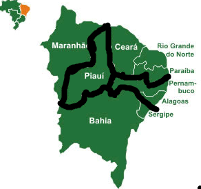
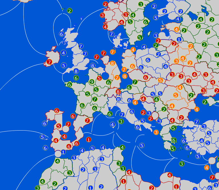
https://www.warlight.net/Play?PreviewMap=53711

I initially was modeling it off of world nations as much as possible, and the bonuses were all black for a while. However, early on in the development process I decided it would be much easier to make scenarios if somehow you could easily tell which countries were which. The two viable options IMO were either bonus links for each country, or coloring each countries territories as to not have any bordering countries which share the same color. I chose the latter since it would likely result in a smaller file size with less bonus links.

I went with this theory for a while, but while making scenarios myself during development, I decided that it's waaaaay too hard with a map of this size to select each territory individually, so I started adding in bonus links as well. This approach is better anyway since it allows people to select every territory in a country at once, which is really awesome IMO.

So, with the color code pretty much obsoleted, It basically comes down to if the map looks better with black borders or colored ones. I'd like to get some thoughts on this, since I don't really have an answer myself, and it's pretty much you guys who are mostly going to be playing the map after I finish making it :)
All black vs Different colors for each country: 3/3/2016 18:00:36


Zephyrum
Level 60
Report
Definetely keep the colors. It makes the map several hundred times more appealing.

No real need for the bonuses for countries imo (other than quicker to make russia/USA). On the inside we all know the countries' form. Sorta.
All black vs Different colors for each country: 3/3/2016 18:06:26


GeneralPE
Level 56
Report
just make them 0-value bonuses like in Ocassus University. And keep the color- this looks so much better than World Nations
All black vs Different colors for each country: 3/3/2016 18:37:06


Imperator
Level 53
Report
Oh, well Okay :) To be honest I think it looks much better as well, it's just that WN is so popular, I'm not really sure which people really prefer.

If the svg gets too too big I think I'll have to take the bonus links out again, but I don't really want to do that unless I absolutely have to. They are pretty convenient for making custom scenarios.
All black vs Different colors for each country: 3/3/2016 19:52:33


Ox
Level 58
Report
+1 GeneralPE

Love it more than ever! :D
All black vs Different colors for each country: 3/3/2016 20:23:34


Imperator
Level 53
Report
Don't worry ox, I've got your list, I'll do some more of your stuff, I'm just procrastinating a bit on it :P
All black vs Different colors for each country: 3/3/2016 21:12:17


OnlyThePie
Level 54
Report
Color looks better. I'd leave the country bonuses all as one. I don't like the 0 feature on Ox's map because then I can't actually see the specific borders of my country.
All black vs Different colors for each country: 3/3/2016 21:30:53


Ox
Level 58
Report
Don't really worry. Most of it was nitpicking, and the only actual crucial areas were Poland and Romania, and they were fixed really quickly!

Only major point though: Change the bonus 'United Kingdom of Great Britain & Northern Ireland' to its official name: 'United Kingdom of Scotland, Wales and Northern Ireland, as well as the scum of England'.
All black vs Different colors for each country: 3/4/2016 01:21:47


Zephyrum
Level 60
Report
WOOT! Now I just checked the map (my reply was when I was in a driving class and I couldn't see the link).

It's going great :DDD I'll be there to nitpick when you start South America. :P

Rename needed: Ottowa -> Ottawa (typo)

Arkhangelsk -> Novaya Zemlya (there are two Arkhangelsks on the map, one in it's actual location and one in the island of Novaya Zemlya)

It's the map I'm most hyped to ^-^
All black vs Different colors for each country: 3/4/2016 01:48:59


Imperator
Level 53
Report
Yeah I know, I've still got a bunch of stuff from before that you suggested, but I'll have to do it some other time lol. My least favorite part of doing a map is redoing stuff, so I'm saving most of it for the very last minute.

The thing about Arkhangelsk is that Those islands actually belong to arkhangelsk, funny as it is. For russia, due to various reasons, I decided it would be much easier to name the territories after the actual administrative divisions that they're based off of rather than the largest city in the division as I've done elsewhere. I probably will rename the islands later on tonight, but right now I'm kind of tied up trying to get the map uploaded with china included. As of now a huge chunk of europe has gone missing due to by being careless :(

Edited 3/4/2016 01:50:53
All black vs Different colors for each country: 3/4/2016 01:58:07


Zephyrum
Level 60
Report
If possible be innovative and be the first mapmaker to make a decent map of Brazil! :D And by that I mean make all states a territory. Ain't that hard, it's just 26 (27 if you count the federal district with the capital). We got the world's 7th GDP, so it's definetely not a waste and the fifth land area so you have plenty of space for it!)

Maybe the northeastern states will give quite a headache, and maybe you'll have to merge some, but a good split would go like this (if you really need the space; and Bahia can be split into two since the inner parts of it is clay we *graciously* took from Pernambuco when they were getting too cozy with the dutch. The coast however is the only part of the state that matters, the one I'm in and where we have civilized big cities. Inner Bahia is basically small mountains and then a small desert):


On an unrelated note, I caught this abomination in Europe :P

All black vs Different colors for each country: 3/4/2016 02:06:55


Imperator
Level 53
Report
I'm trying to get the svg uploaded with China included, which I did succeed in doing eventually, but it came at a terrible price lol :D It's probably going to take me ~20 minutes to fix it I'd imagine.

I'm probably going to finish up china once I get europe fixed again, then finish up Bhutan, Nepal, Korea, indochina, etc before moving on to south america. Then you can grill me about my terrible judgement on merging stuff in brazil :P
All black vs Different colors for each country: 3/4/2016 02:07:53


Zephyrum
Level 60
Report
If you want to, I can just send you a good merge/split suggestion on a map :p
All black vs Different colors for each country: 3/4/2016 03:02:11


Imperator
Level 53
Report
Sure, The less redoing I have to go through the better :)
All black vs Different colors for each country: 3/4/2016 03:17:52


Zephyrum
Level 60
Report
It's past midnight here and I'm going to hit the sack. Mail me anytime, and around ~12am here I'll send you a division that does just fine.

Do specify some details, though; how many territories you want/expect, for example.

Edited 3/4/2016 03:18:02
All black vs Different colors for each country: 3/4/2016 05:24:29


{W.U} Francisco Corral
Level 56
Report
Out of curiosity what criteria are you using to name the territories, I am looking at Mexico and some have the names of the State (like Veracruz) while others are names of cities even though its the whole state (like Tijuana).
All black vs Different colors for each country: 3/4/2016 05:44:55


Imperator
Level 53
Report
In most countries, the territory is named after the largest city in the region. This isn't true for some countries, the big one that comes to mind is russia, where the territory names are named after the regions they're based on.

The example you cited is simply a case of Veracruz being the largest city in the veracruz state, Resulting in the territory being named Veracruz. There are inconsistencies in naming in that I used region names in some countries and city names in others, but all naming is internally consistent in that countries with region names are actually region names and not cities and vice versa.
All black vs Different colors for each country: 3/4/2016 06:45:20


xXOmegaXx
Level 55
Report
Coloured is defineatly better, especialy this scheme where you have 4 colours that you cycle throigh. Are maps like these usually black, because it looks better on view selected territories or something?

Also, the new GDP bonuses look really good - a major improvement on the original idea.
All black vs Different colors for each country: 3/4/2016 16:14:56


Imperator
Level 53
Report
The only possible advantage I can think of for all black borders is that it's politically neutral, and you can build your own nation pretty easily in a role-playing game. Taking for example Czech Republic, Munich, Vienna and Slovakia on a black map gets you what can be reasonably taken for a nation, since all the borders are the same color. Take those territories on my map as it is now, You get a red one, an orange one, a green one and another orange one.

I did do some test games and it isn't a huge problem since your color fills in the territory, making it very clear that all this land is unified, but IMO it still is a small disadvantage.
All black vs Different colors for each country: 3/4/2016 16:31:32


Zephyrum
Level 60
Report
Not a big enough if you ask me.
Posts 1 - 20 of 56   1  2  3  Next >>