<< Back to Map Development Forum   Search

Posts 1 - 17 of 17   
British Isles Map: 12/10/2012 21:46:55


Mr.Brockavitch
Level 2
Report
Is there anyone else who thinks the British Isles map on here is small and boring, I suggest a new one should be made, however I've tried my hand at map building and I'm awful. So if there is anyone who can build maps and is willing to make this idea into a map then I'd be grateful and we would have a wonderful new map for everyone to enjoy. The way I see it, it should use Boroughs as territories, counties for bonuses and countries for large bonuses. Thanks for anyone who is willing to help build this map or simply agree it would be a good idea.
British Isles Map: 12/10/2012 21:49:50

Will
Level 4
Report
I agree; there are plenty of large maps of other countries, but none of good old Blighty. Unfortunately, I also lack any kind of skill in map building.
British Isles Map: 12/11/2012 09:13:52


Moros 
Level 50
Report
British Isles Map: 12/11/2012 13:21:13


Addy the Dog 
Level 62
Report
The shape of Britain is a bit shitty for a decent map. You have the appendages of Cornwall and Scotland which are awkward to get to. With the maps moros picked out, there is also the problem that some are much larger than others, which results in an unbalanced map.

The best idea would be one of just England and Wales, but that would result in the sort of non-descript blob that is usually the product of a real-world map. Otherwise, you could try to incorporate mountains and larger rivers as barriers. I think I'll try that one day.

I am working on a map of Scotland, which could go ok, since the geography is a little more interesting, with the islands. The bonuses will be what is shown by moros in his map, and the territories will be drawn by hand and named after towns and cities.
British Isles Map: 12/11/2012 16:48:20


Mr.Brockavitch
Level 2
Report
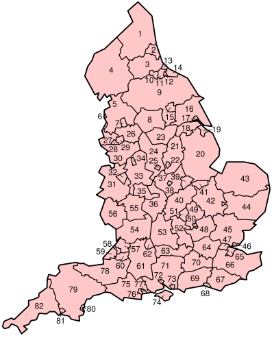
Those maps don't include further denominations of the counties. There are a good few hundred boroughs/parishes/districts that make up England alone and a good few in each county. So the unbalanced issue is easily resolved.
British Isles Map: 12/11/2012 16:55:48


Mr.Brockavitch
Level 2
Report

this is an example of one of the counties (Warrickshire) split into possible territories
British Isles Map: 12/11/2012 17:09:42


Addy the Dog 
Level 62
Report
so essentially a large usa map but the uk? yeah, i think i could do that. do you have a single image that includes all of the territories?
British Isles Map: 12/11/2012 17:28:21


Mr.Brockavitch
Level 2
Report
No I don't but I could get the counties individually
British Isles Map: 12/11/2012 17:37:39


Mr.Brockavitch
Level 2
Report
There is also this map of political constituencies which number around 400 I think.

http://www.telegraph.co.uk/news/politics/2432632/UK-General-Election-2010-political-map.html
British Isles Map: 12/11/2012 17:43:00


Addy the Dog 
Level 62
Report
yeah, thats no good because some territories are so much larger than others.
British Isles Map: 12/11/2012 17:48:18


Mr.Brockavitch
Level 2
Report
yeah I thought that.... good number of territories though. I guess the best thing i to go with the one's from the picture and similar from each county and make it massive.
British Isles Map: 12/11/2012 21:53:04

MasteƦMind
Level 54
Report
Ok I can make it if you want looking to make a map.
British Isles Map: 12/12/2012 16:11:56


Mr.Brockavitch
Level 2
Report
That would be really good :) would you be able to piece it together from separate counties or would you need a map of all the British Isles?
British Isles Map: 12/12/2012 19:21:46

MasteƦMind
Level 54
Report
year seperate county's then i can join them together
British Isles Map: 12/13/2012 17:13:54

MasteƦMind
Level 54
Report
i am starting on the warickdhire part if you could find more that would be great.
British Isles Map: 12/14/2012 16:19:49


Mr.Brockavitch
Level 2
Report
yeah sure :)
British Isles Map: 12/16/2012 17:11:46


Mr.Brockavitch
Level 2
Report
Posts 1 - 17 of 17