<< Back to Map Development Forum   Search

Posts 1 - 11 of 11   
Europe 1914: New historicaly Accurate Map Comming Soon!: 12/5/2012 20:51:36


skunk940 
Level 60
Report
While Africa Billike is under its last testings and editings, (Its is set to be published in the next couple of days,) I have been working on a historically acurate map of Europe 1914. I am fed up of Seeing 'WWW1' maps of Europe which are incorect. So i made this. It is perfect for roleplays and general playing. I am doing a couple of test games and i need some volentiers.

Heres a preview of it: http://warlight.net/SinglePlayer?PreviewMap=17369

So eneyone interested in helping test it?
Europe 1914: New historicaly Accurate Map Comming Soon!: 12/5/2012 21:11:26


Min34 
Level 63
Report
Missing links:
Germany - France
Germany - Switzerland
Russia - Rumania
Europe 1914: New historicaly Accurate Map Comming Soon!: 12/5/2012 23:24:08

Darth Mylor {Warlighter}
Level 13
Report
Also, it is not called Rumania. It is called Romania
Europe 1914: New historicaly Accurate Map Comming Soon!: 12/6/2012 09:30:17


no one
Level 57
Report
test
Europe 1914: New historicaly Accurate Map Comming Soon!: 12/6/2012 16:13:21


skunk940 
Level 60
Report
Missing link added, Darth Mylor acording to my many sources its Rumania. Whever thats beacouse you can write it both ways or it changed its name i dont know.
Europe 1914: New historicaly Accurate Map Comming Soon!: 12/9/2012 19:55:25

alih10 
Level 25
Report
Looks good, but I'm a bit confused with all the pieces of Britain lying around Europe, test?
Europe 1914: New historicaly Accurate Map Comming Soon!: 12/9/2012 21:55:37


hey 
Level 37
Report
Should the "Allie Nations" bonus be called Allied Nations? If you still need people to test I can help.
Europe 1914: New historicaly Accurate Map Comming Soon!: 12/10/2012 16:19:27


skunk940 
Level 60
Report
Its Allie as in the group like Axis. If what was ally then it would be allied but as its not its not. thanks for raising that though.

On the other hand i dont need any more help but if i do i will let you know. Thansk for asking.
Europe 1914: New historicaly Accurate Map Comming Soon!: 12/10/2012 18:42:08


Moros 
Level 50
Report
1. Wikipedia says Romania is the official spelling, and Rumania and Roumania are dated.
2. Allied nations is correct.
3. Skunk, still no attention to the overlapping borders...
4. The bonuslinks in the topleft corner may seem nice, but the numbers are unreadable for the Allied and Neutrals.
5. If you want to make an historically accurate map, you failed, because now Germany is just as easy to conquer as Luxembourg.
6. Arabia, is that even a country?
7. The bits of the UK (incorrectly named Britain here) spread across the map may be correct, but are very annoying. Just imagine what the UK would look like in the small viewbox in a game when you select it. Not to mention that the French and Spanish parts of Africa are territories of them own.
8. Why is there a border in Ireland, when it's all the same territory?
9. Asia Blockade? What in the world does that mean?
10. Far East isn't so far east.
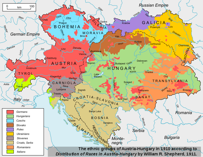
11. Austria-Hungary also occupied the Adriatic Islands.
Proof:
Europe 1914: New historicaly Accurate Map Comming Soon!: 12/11/2012 17:04:49


skunk940 
Level 60
Report
Overlapping borders is a slight problem but its there to prevent gaps. My current map making methods are constantly changing to try and get the highest leval of quality.
The bonuslink in the top right corner is unfixable. If only warl;ight had a set center ability for bonuses. The map is historicly accurate in the snese of names and borders. Not country defense as this is only a 1:1 territory to countrie map.
Arabia was a county. The name Britain was the commen name back then, nowadays both the names Britain and UK are acepted. The French Morocco and Spanish Morocco were owned by the Spanish and French but where seperate nations. They had there own goverments and leaders.
The border in ireland is a semi border. You just have to trust me on that.
The Asia blockade is there to prent confusion as most of the area East to Afghanistan was owned by other nations. Eg: India was owned by Britain. The Asia blockade is there to prevent the map getting complicated. Also a similar blockade did acturlly exsist.
The far East bonuse is far east for Europe as this is a Europe map. Afghanistan is normally considered as Asian.
With the islands at the start of 1914 they where under much change. There are over 1300 island in the Adriatic sea and the ones i picked out belonged to Italy.
Europe 1914: New historicaly Accurate Map Comming Soon!: 12/12/2012 04:13:35


i-like-swords
Level 31
Report
The borders of the countries are historically correct (except for the deal with the Dalmatian islands), but most of the countries are better off split into bonuses, like splitting Austria-Hungary into Austria, Hungary, and Bosnia; or the UK into England, Scotland, Wales, and Ireland.

Note: Finland was actually an autonomous duchy within the Russian Empire, so should you try to make it historically accurate, you have to merge it with Russia or otherwise
split Russia up.
Posts 1 - 11 of 11