<< Back to Map Development Forum   Search

Posts 1 - 12 of 12   
Dietsland (The Netherlands + Flanders): 7/2/2017 13:11:16


[VL] Tristaneke
Level 28
Report
Hey

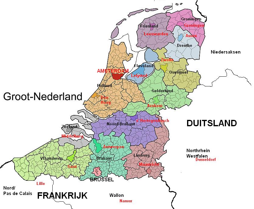
I had thought of seeing the Netherlands and Flanders in a map, Great Netherlands (Dietsland).
I would appreciate if anyone would like to make it, maybe interesting to the Flemish and Dutch among us.

- I would like the sea to be blue and perhaps the text 'North Sea' will be included.

- In the upper left corner, maybe Dietsland or United Kingdom of the Netherlands as text and the prince flag (orange / white / blue, horizontal)

- Land borders with Germany / France do not make too detailed such as the Benelux map of Willem, no land borders are also fine.

- St. Maarten, Aruba, Saba, Saint Eustatius, Curacao, Bonaire (Netherlands Antilles) may also be placed in a similar separate subject as in the folder but you do not need to do it in detail. Https://www.warlight.net/MultiPlayer?GameID=13323802

- Brussels is a complex case because I do not think it will be part of Flanders, but it may be a place that can be left out of the map, I do not care.

- 2 big bonuses namely the Netherlands and Flanders, with a flag. (Flemish lion and the Dutch flag)

- The texture of the directory of https://www.warlight.net/MultiPlayer?GameID=13323802 I find this absolutely beautiful, the provinces are nicely divided, easy and attractive to play as a folder.

- About 1500 areas would be ideal for such a map, I would leave North-West-East in a city, which is a bit superfluous to my mind.

With best regards,

Tristan.
Dietsland (The Netherlands + Flanders): 7/2/2017 13:23:08


[VL] Tristaneke
Level 28
Report
Dietsland (The Netherlands + Flanders): 7/2/2017 18:44:30


Belgian Gentleman
Level 57
Report
Mr. Flanderson approves
Dietsland (The Netherlands + Flanders): 7/2/2017 23:36:39


Жұқтыру
Level 56
Report
Yet another map of Benelux after the thousands after all that there are? Oh well, do what you want.
Dietsland (The Netherlands + Flanders): 7/3/2017 09:12:59


[VL] Tristaneke
Level 28
Report
It's not another map of Benelux, i know there are too many maps of the same area but this one is different trust me.

Benelux stands for Belgium + Netherlands + Luxembourg 3 countries in one map.

The Netherlands and Flanders (half of Belgium) is not the SAME, don't be so annoyed about it, if you don't like it beat it.
Dietsland (The Netherlands + Flanders): 7/3/2017 09:42:52


Dutch Desire 
Level 60
Report
Why not make a map of the current and historical european region where Dutch is or was spoken?
So the brown and orange gerion of this map:
https://upload.wikimedia.org/wikipedia/commons/2/21/Nederlandstaalgebied.png
Dietsland (The Netherlands + Flanders): 7/3/2017 12:56:22


[VL] Tristaneke
Level 28
Report
that could be another map. It's a good idea, but if anyone want to design this map, tell me! :D
Dietsland (The Netherlands + Flanders): 7/3/2017 14:09:20


Belgian Gentleman
Level 57
Report
http://nsm03.casimages.com/img/2010/05/13//100513090734970736025500.jpg

I found a better map that replaces the old one
Dietsland (The Netherlands + Flanders): 7/3/2017 16:50:44


[VL] Tristaneke
Level 28
Report
Yes that's true, but there are villages in the West-Flanders that are Flemish-speaking but it belongs to France. so that's why i didn't take it as an example
Dietsland (The Netherlands + Flanders): 7/3/2017 17:06:31


Belgian Gentleman
Level 57
Report
I think you are referring to French-Flanders, not West-Flanders ;)
Dietsland (The Netherlands + Flanders): 7/3/2017 19:27:02


[VL] Tristaneke
Level 28
Report
Yes French-Flanders bordering West-Flanders (West-Vlaanderen) ;)
Dietsland (The Netherlands + Flanders): 7/6/2017 08:32:20


Murk 
Level 57
Report
Inkscape is free to download, and learning to trace a map will take you half an hour at most.
It will barely be any more work for you than for anyone else.

So, I'd say, go ahead! Make this map! You already got all the maps you want and a clear image in your mind, so what are you waiting for?
Posts 1 - 12 of 12